Geolocate

Cedar Island topographic map

Interactive map

Click on the map to display elevation.

About this map

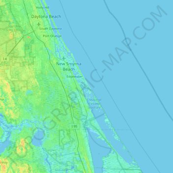
Name: Cedar Island topographic map, elevation, terrain.

Location: Cedar Island, Volusia County, Florida, 32141, United States (28.63003 -81.17108 29.27003 -80.53108)

Average elevation: 3 m

Minimum elevation: -4 m

Maximum elevation: 40 m

Other topographic maps

Click on a map to view its topography, its elevation and its terrain.

Port Orange

United States > Florida > Volusia County

Average elevation: 6 m

Ormond Beach

United States > Florida > Volusia County

Average elevation: 3 m

Deltona

United States > Florida > Volusia County

The majority of the land in the city is of karst topography, characterized by rolling hills and an abundant amount of lakes. The St. Johns River passes through Lake Monroe, directly south of the city. The United States Geological Survey lists the city's elevation at 33 feet (10 m) above sea level at a point…

Average elevation: 12 m

Edgewater

United States > Florida > Volusia County

Average elevation: 4 m

DeLand

United States > Florida > Volusia County

DeLand features a varied topography characterized primarily by gentle slopes and a mix of wetlands and uplands. The city covers approximately 17.8 square miles, with about 17.6 square miles of land and a small percentage dedicated to water bodies. The elevation in DeLand is relatively modest, typically ranging…

Average elevation: 20 m

DeBary

United States > Florida > Volusia County

Average elevation: 10 m

DeLeon Spring

United States > Florida > Volusia County

Average elevation: 12 m

Deltona

United States > Florida > Volusia County

The majority of the land in the city is of karst topography, characterized by rolling hills and an abundant amount of lakes. The St. Johns River passes through Lake Monroe, directly south of the city. The United States Geological Survey lists the city's elevation at 33 feet (10 m) above sea level at a point…

Average elevation: 12 m

Orange City

United States > Florida > Volusia County

Average elevation: 18 m

Pierson

United States > Florida > Volusia County

Average elevation: 14 m

DeLand

United States > Florida > Volusia County

Average elevation: 20 m

South Daytona

United States > Florida > Volusia County

According to the United States Census Bureau, the city has a total area of 5.0 square miles (13.0 km2), of which 3.7 square miles (9.6 km2) is land and 1.3 square miles (3.4 km2) (26.29%) is water. There are nearly 44.5 miles (71.6 km) of roadway, 40 miles (64 km) of sewer lines, and 55 miles (89 km) of water…

Average elevation: 4 m

Deltona

United States > Florida > Volusia County

The majority of the land in the city is of karst topography, characterized by rolling hills and an abundant amount of lakes. The St. Johns River passes through Lake Monroe, directly south of the city. The United States Geological Survey lists the city's elevation at 33 feet (10 m) above sea level at a point…

Average elevation: 12 m

Ormond Beach

United States > Florida > Volusia County

Average elevation: 3 m

Deltona

United States > Florida > Volusia County

The majority of the land in the city is of karst topography, characterized by rolling hills and an abundant amount of lakes. The St. Johns River passes through Lake Monroe, directly south of the city. The United States Geological Survey lists the city's elevation at 33 feet (10 m) above sea level at a point…

Average elevation: 12 m

Ponce Inlet

United States > Florida > Volusia County

Average elevation: 1 m

Ormond Beach

United States > Florida > Volusia County

Average elevation: 3 m

Lake Helen

United States > Florida > Volusia County

Average elevation: 21 m

Oak Hill

United States > Florida > Volusia County

Average elevation: 3 m

Louise Lake

United States > Florida > Volusia County > Deltona

Average elevation: 11 m

Glencoe

United States > Florida > Volusia County > Glencoe

Average elevation: 8 m

Holly Hill

United States > Florida > Volusia County

Average elevation: 4 m

Edgewater

United States > Florida > Volusia County

Average elevation: 4 m

Port Orange

United States > Florida > Volusia County

Average elevation: 6 m

Orange City

United States > Florida > Volusia County

Average elevation: 18 m

Pierson

United States > Florida > Volusia County

Average elevation: 14 m

Lake Helen

United States > Florida > Volusia County

Average elevation: 21 m