Geolocate

Zeutern topographic map

Click on the map to display elevation.

About this map

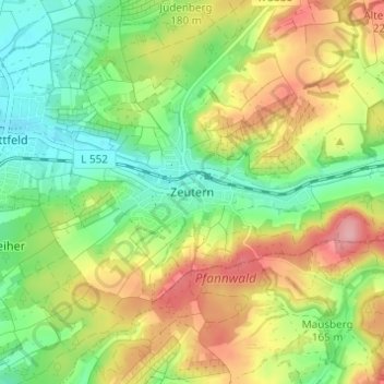
Name: Zeutern topographic map, elevation, terrain.

Location: Zeutern, Ubstadt-Weiher, Landkreis Karlsruhe, Baden-Württemberg, 76698, Germany (49.15647 8.65520 49.19647 8.69520)

Average elevation: 170 m

Minimum elevation: 116 m

Maximum elevation: 242 m

Other topographic maps

Click on a map to view its topography, its elevation and its terrain.

Stutensee

Germany > Baden-Württemberg > Landkreis Karlsruhe

The city is situated between Karlsruhe and Bruchsal in the Upper Rhine region and its altitude is 114 m (374 ft).

Average elevation: 118 m

Gear up for your next adventure:

Insulated Travel Mugs - Keep drinks hot while surveying the landscape from a summit
🔦Outdoor Torches - Reliable torches for night navigation
🛌Sleeping Mats - Insulated mats for comfortable outdoor sleeping
🍱Food Containers - Reusable containers for outdoor meals
🗺️Topographic Maps - Detailed maps showing elevation and terrain features

As an Amazon Associate, this site earns from qualifying purchases at no extra cost to you.