
Gangkofen topographic map
Interactive map
Click on the map to display elevation.
About this map
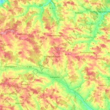
Name: Gangkofen topographic map, elevation, terrain.
Location: Gangkofen, Landkreis Rottal-Inn, Bavaria, 84140, Germany (48.39961 12.47006 48.52481 12.65428)
Average elevation: 471 m
Minimum elevation: 410 m
Maximum elevation: 523 m
Other topographic maps
Click on a map to view its topography, its elevation and its terrain.
Walking
Germany > Bavaria > Landkreis Rottal-Inn > Wittibreut
Walking, Wittibreut, Landkreis Rottal-Inn, Bavaria, 84384, Germany
Average elevation: 504 m
Pfarrkirchen
Germany > Bavaria > Landkreis Rottal-Inn
Pfarrkirchen, Landkreis Rottal-Inn, Bavaria, 84347, Germany
Average elevation: 429 m
Putting
Germany > Bavaria > Landkreis Rottal-Inn > Wurmannsquick
Putting, Wurmannsquick, Landkreis Rottal-Inn, Bavaria, 84329, Germany
Average elevation: 464 m
Hintergrindering
Germany > Bavaria > Landkreis Rottal-Inn > Seemannshausen
Hintergrindering, Seemannshausen, Gangkofen, Landkreis Rottal-Inn, Bavaria, 84140, Germany
Average elevation: 468 m
Gindering
Germany > Bavaria > Landkreis Rottal-Inn > Gangkofen
Gindering, Gangkofen, Landkreis Rottal-Inn, Bavaria, 84140, Germany
Average elevation: 465 m
Simbach
Germany > Bavaria > Landkreis Rottal-Inn
Simbach, Landkreis Rottal-Inn, Bavaria, 84359, Germany
Average elevation: 425 m