
Make a donation
Gear up for your next adventure:
As an Amazon Associate, this site earns from qualifying purchases at no extra cost to you.
Quickborn topographic map
Click on the map to display elevation.
Make a donation
Gear up for your next adventure:
As an Amazon Associate, this site earns from qualifying purchases at no extra cost to you.
About this map
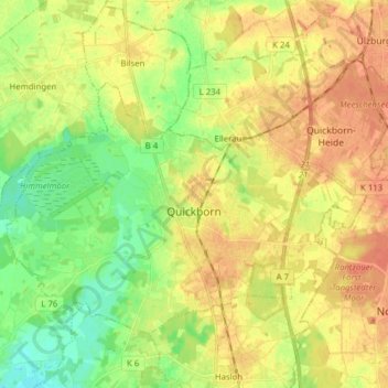
Name: Quickborn topographic map, elevation, terrain.
Location: Quickborn, Kreis Pinneberg, Schleswig-Holstein, 25451, Germany (53.70363 9.82613 53.76975 9.98302)
Average elevation: 23 m
Minimum elevation: 3 m
Maximum elevation: 39 m
Make a donation
Gear up for your next adventure:
As an Amazon Associate, this site earns from qualifying purchases at no extra cost to you.
Other topographic maps
Click on a map to view its topography, its elevation and its terrain.
Heligoland
Germany > Schleswig-Holstein > Kreis Pinneberg > Helgoland > Helgoland
Average elevation: 2 m
Make a donation
Gear up for your next adventure:
As an Amazon Associate, this site earns from qualifying purchases at no extra cost to you.