
Make a donation
Gear up for your next adventure:
As an Amazon Associate, this site earns from qualifying purchases at no extra cost to you.
les Cabanyes topographic map
Click on the map to display elevation.
Make a donation
Gear up for your next adventure:
As an Amazon Associate, this site earns from qualifying purchases at no extra cost to you.
About this map
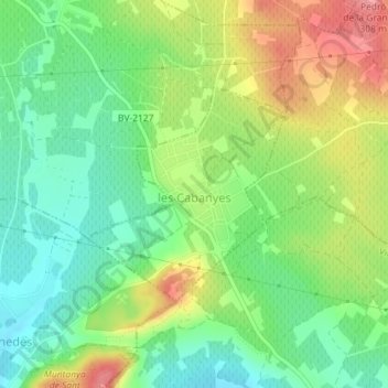
Name: les Cabanyes topographic map, elevation, terrain.
Location: les Cabanyes, Alt Penedès, Barcelona, Catalonia, 08794, Spain (41.36432 1.67946 41.37917 1.69783)
Average elevation: 247 m
Minimum elevation: 206 m
Maximum elevation: 306 m
Make a donation
Gear up for your next adventure:
As an Amazon Associate, this site earns from qualifying purchases at no extra cost to you.
Other topographic maps
Click on a map to view its topography, its elevation and its terrain.
les Casetes del Pujol
Spain > Catalonia > Alt Penedès > Castellví de la Marca > la Múnia
Average elevation: 185 m
Make a donation
Gear up for your next adventure:
As an Amazon Associate, this site earns from qualifying purchases at no extra cost to you.