Geolocate

Agency topographic map

Click on the map to display elevation.

About this map

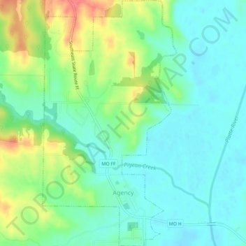
Name: Agency topographic map, elevation, terrain.

Location: Agency, Buchanan County, Missouri, United States (39.64060 -94.75861 39.67505 -94.73424)

Average elevation: 270 m

Minimum elevation: 248 m

Maximum elevation: 316 m

Other topographic maps

Click on a map to view its topography, its elevation and its terrain.

Wallace

United States > Missouri > Buchanan County

Average elevation: 327 m

Faucett

United States > Missouri > Buchanan County

Average elevation: 305 m

Sugar Lake

United States > Missouri > Buchanan County

Average elevation: 255 m

Lake Station

United States > Missouri > Buchanan County

Average elevation: 253 m

Gear up for your next adventure:

🩹Hiking First Aid Kits - Compact medical kits tailored for trail injuries and emergencies
🛰️Handheld GPS Devices - Reliable GPS units for hiking and outdoor navigation
🎒Hiking Daypacks - Compact backpacks ideal for short hikes and excursions
🧺Mesh Stuff Sacks - Breathable storage for wet gear or camp organization
🛰️Satellite Messengers - Emergency communication devices for areas without mobile signal

As an Amazon Associate, this site earns from qualifying purchases at no extra cost to you.