
Thank you for supporting this site ❤️
Make a donation
Make a donation
Gear up for your next adventure:
As an Amazon Associate, this site earns from qualifying purchases at no extra cost to you.
Tanauan topographic map
Click on the map to display elevation.
Thank you for supporting this site ❤️
Make a donation
Make a donation
Gear up for your next adventure:
As an Amazon Associate, this site earns from qualifying purchases at no extra cost to you.
About this map
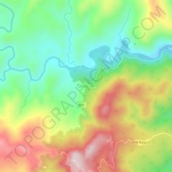
Name: Tanauan topographic map, elevation, terrain.
Location: Tanauan, Real, Quezon, Calabarzon, Philippines (14.53677 121.57293 14.57677 121.61293)
Average elevation: 202 m
Minimum elevation: 14 m
Maximum elevation: 459 m
Thank you for supporting this site ❤️
Make a donation
Make a donation
Gear up for your next adventure:
As an Amazon Associate, this site earns from qualifying purchases at no extra cost to you.
Other topographic maps
Click on a map to view its topography, its elevation and its terrain.
Laguna-Quezon Land Grant Lagoon
Philippines > Quezon > Real > Magsaysay > Maunlad
Average elevation: 389 m