
Make a donation
Gear up for your next adventure:
As an Amazon Associate, this site earns from qualifying purchases at no extra cost to you.
Milam Glacier topographic map
Click on the map to display elevation.
Make a donation
Gear up for your next adventure:
As an Amazon Associate, this site earns from qualifying purchases at no extra cost to you.
Milam Glacier
The Bhotiya communities living in the Pithoragarh district historically practised transhumance between summer villages located at higher altitudes, close to the border with Tibet, and winter settlements located at lower altitudes, close to the Himalayan foothills and the Gangetic plains. With transhumance as a base, many of them would engage in annual trade visits to market towns such as Taklakot in western Tibet, and some would practice nomadic pastoralism as well. This way of life came to an abrupt end in the 1962 due to the Sino-Indian War. Trans-Himalayan trade was allowed again since the under 1990s. But unlike in the past, it was now to be conducted under state-imposed regulations and limitations, and was allowed only across the Pithoragarh district's Lipu Lekh pass, whereas in earlier times, in Kumaon and Garwhal, the Trans-Himalayan trade had been conducted across several passes.
Make a donation
Gear up for your next adventure:
As an Amazon Associate, this site earns from qualifying purchases at no extra cost to you.
About this map
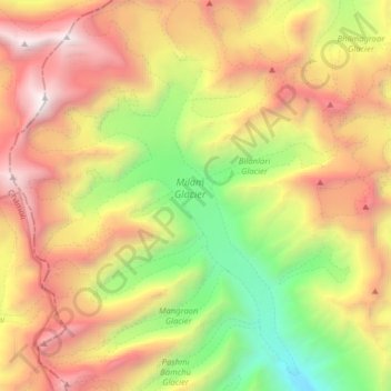
Name: Milam Glacier topographic map, elevation, terrain.
Average elevation: 5,229 m
Minimum elevation: 3,582 m
Maximum elevation: 7,111 m
Make a donation
Gear up for your next adventure:
As an Amazon Associate, this site earns from qualifying purchases at no extra cost to you.
Other topographic maps
Click on a map to view its topography, its elevation and its terrain.
Make a donation
Gear up for your next adventure:
As an Amazon Associate, this site earns from qualifying purchases at no extra cost to you.