
Olot topographic map
Interactive map
Click on the map to display elevation.
About this map
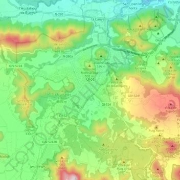
Name: Olot topographic map, elevation, terrain.
Location: Olot, Garrotxa, Gerona, Cataluña, España (42.14974 2.44638 42.20532 2.54909)
Average elevation: 499 m
Minimum elevation: 293 m
Maximum elevation: 881 m
Other topographic maps
Click on a map to view its topography, its elevation and its terrain.
Sales de Llierca
Sales de Llierca, Garrotxa, Gerona, Cataluña, España
Average elevation: 510 m
Sant Privat d'En Bas
España > Cataluña > Garrotxa > la Vall d'en Bas
Sant Privat d'En Bas, la Vall d'en Bas, Garrotxa, Gerona, Cataluña, 17178, España
Average elevation: 735 m