
Make a donation
Gear up for your next adventure:
As an Amazon Associate, this site earns from qualifying purchases at no extra cost to you.
Murangi topographic map
Click on the map to display elevation.
Make a donation
Gear up for your next adventure:
As an Amazon Associate, this site earns from qualifying purchases at no extra cost to you.
About this map
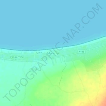
Name: Murangi topographic map, elevation, terrain.
Location: Murangi, Musoma, Mara Region, Lake Zone, Tanzania (-1.86813 33.46141 -1.82813 33.50141)
Average elevation: 1,143 m
Minimum elevation: 1,134 m
Maximum elevation: 1,173 m
Make a donation
Gear up for your next adventure:
As an Amazon Associate, this site earns from qualifying purchases at no extra cost to you.
Other topographic maps
Click on a map to view its topography, its elevation and its terrain.
Mara River
The altitudes in the basin range from 2,932 m around the sources in the Mau Escarpment to 1,134 m around Lake Victoria. The amount of precipitation varies according to these altitudes. The Mau Escarpment receives most rainfall with a mean annual rainfall between 1,000 and 1,750 mm. The transboundary middle…
Average elevation: 1,555 m