
La Brosse topographic map
Interactive map
Click on the map to display elevation.
About this map
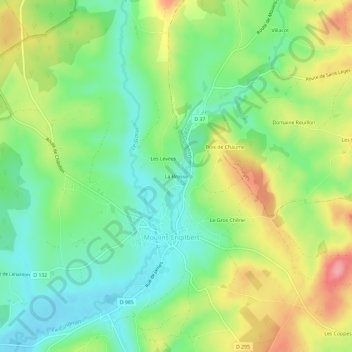
Name: La Brosse topographic map, elevation, terrain.
Average elevation: 263 m
Minimum elevation: 215 m
Maximum elevation: 339 m
Other topographic maps
Click on a map to view its topography, its elevation and its terrain.
Crot Manigot
France > Bourgogne-Franche-Comté > Nièvre > Moulins-Engilbert > Margoulet
Crot Manigot, Margoulet, Moulins-Engilbert, Château-Chinon (Ville), Nièvre, Bourgogne-Franche-Comté, France métropolitaine, 58290, France
Average elevation: 338 m
Les Coppes
France > Bourgogne-Franche-Comté > Nièvre > Moulins-Engilbert
Les Coppes, Moulins-Engilbert, Château-Chinon (Ville), Nièvre, Bourgogne-Franche-Comté, France métropolitaine, 58290, France
Average elevation: 300 m
Les Champs Brideaux
France > Bourgogne-Franche-Comté > Nièvre > Moulins-Engilbert
Les Champs Brideaux, Moulins-Engilbert, Château-Chinon (Ville), Nièvre, Bourgogne-Franche-Comté, France métropolitaine, 58290, France
Average elevation: 294 m
Moulin de Commagny
France > Bourgogne-Franche-Comté > Nièvre > Moulins-Engilbert > Compagny le Prieuré
Moulin de Commagny, Compagny le Prieuré, Moulins-Engilbert, Château-Chinon (Ville), Nièvre, Bourgogne-Franche-Comté, France métropolitaine, 58290, France
Average elevation: 245 m