
Thank you for supporting this site ❤️
Make a donation
Make a donation
Gear up for your next adventure:
As an Amazon Associate, this site earns from qualifying purchases at no extra cost to you.
Carora topographic map
Click on the map to display elevation.
Thank you for supporting this site ❤️
Make a donation
Make a donation
Gear up for your next adventure:
As an Amazon Associate, this site earns from qualifying purchases at no extra cost to you.
About this map
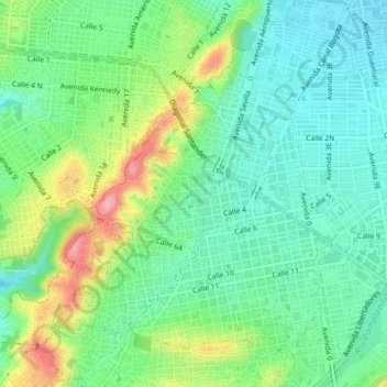
Name: Carora topographic map, elevation, terrain.
Location: Carora, Cúcuta, Oriental, Norte de Santander, 540006, Colombia (7.87445 -72.53109 7.91445 -72.49109)
Average elevation: 326 m
Minimum elevation: 284 m
Maximum elevation: 415 m
Thank you for supporting this site ❤️
Make a donation
Make a donation
Gear up for your next adventure:
As an Amazon Associate, this site earns from qualifying purchases at no extra cost to you.