
Make a donation
Gear up for your next adventure:
As an Amazon Associate, this site earns from qualifying purchases at no extra cost to you.
Lanaken topographic map
Click on the map to display elevation.
Make a donation
Gear up for your next adventure:
As an Amazon Associate, this site earns from qualifying purchases at no extra cost to you.
Lanaken
Lanaken is characterized by being located on the southern edge of the Kempen Plateau, separated from the more southern region of Haspengouw by the Albert Canal. To the southeast, Lanaken is cut off from Smeermaas and the Maas basin by the Briegden-Neerharen Canal. Lanaken itself lies at an altitude of about 60 meters, to the northwest one finds steep edges to the plateau, which reaches heights of up to 100 meters, and the deeply cut valleys of the brooks Asbeek and Ziepbeek. This part, which is part of the Hoge Kempen National Park, has marshy lowlands, heaths, and forests, consisting of coniferous forest, once planted for the production of mining wood, and mixed forest. The most famous areas are Pietersembos and Asbroek.
Make a donation
Gear up for your next adventure:
As an Amazon Associate, this site earns from qualifying purchases at no extra cost to you.
About this map
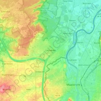
Name: Lanaken topographic map, elevation, terrain.
Location: Lanaken, Tongeren, Limburg, Flanders, Belgium (50.83325 5.57053 50.94453 5.72460)
Average elevation: 66 m
Minimum elevation: 33 m
Maximum elevation: 128 m
Make a donation
Gear up for your next adventure:
As an Amazon Associate, this site earns from qualifying purchases at no extra cost to you.