
Make a donation
Gear up for your next adventure:
As an Amazon Associate, this site earns from qualifying purchases at no extra cost to you.
Podlaskie Voivodeship topographic map
Click on the map to display elevation.
Make a donation
Gear up for your next adventure:
As an Amazon Associate, this site earns from qualifying purchases at no extra cost to you.
Podlaskie Voivodeship
It has a varied landscape, shaped in the north by Baltic glaciation, the rest by Middle Poland glaciation. The highest peaks are in the north (Rowelska Top - 298 m), where the landscape is dominated by a hilly lake district. Lakeland: Zachodniosuwalskie, Wschodniosuwalskie, Ełckie) and Sandrowy lake district (Augustów Plain) in the central and southern pre-glacial plains prevail (plateaus: Kolneńska, Białystok, Wysokomazowiecka, Drohiczynska, Sokólskie Hills, Międzyrzecko łomżyński, Plain Bielsko), varied in topography with small basins and river valleys. Kurpie lies on the west edge of the outwash plains. Sand, gravel, clay, moraine, and in the valleys and basins of the rivers silt, sand and river peat predominate on the surface.
Make a donation
Gear up for your next adventure:
As an Amazon Associate, this site earns from qualifying purchases at no extra cost to you.
About this map
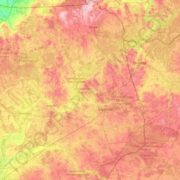
Name: Podlaskie Voivodeship topographic map, elevation, terrain.
Location: Podlaskie Voivodeship, Poland (52.27994 21.59284 54.41040 23.94628)
Average elevation: 138 m
Minimum elevation: 30 m
Maximum elevation: 290 m
Make a donation
Gear up for your next adventure:
As an Amazon Associate, this site earns from qualifying purchases at no extra cost to you.
Other topographic maps
Click on a map to view its topography, its elevation and its terrain.
Make a donation
Gear up for your next adventure:
As an Amazon Associate, this site earns from qualifying purchases at no extra cost to you.
Make a donation
Gear up for your next adventure:
As an Amazon Associate, this site earns from qualifying purchases at no extra cost to you.
Warsaw
Poland > Masovian Voivodeship > Warsaw
Warsaw lies in east-central Poland about 300 kilometres (190 mi) from the Carpathian Mountains and about 260 kilometres (160 mi) from the Baltic Sea, 523 kilometres (325 mi) east of Berlin, Germany. The city straddles the Vistula River. It is located in the heartland of the Masovian Plain, and its average…
Average elevation: 95 m
Make a donation
Gear up for your next adventure:
As an Amazon Associate, this site earns from qualifying purchases at no extra cost to you.
Make a donation
Gear up for your next adventure:
As an Amazon Associate, this site earns from qualifying purchases at no extra cost to you.
Make a donation
Gear up for your next adventure:
As an Amazon Associate, this site earns from qualifying purchases at no extra cost to you.
Warsaw
Poland > Masovian Voivodeship > Warsaw
Warsaw lies in east-central Poland about 300 kilometres (190 mi) from the Carpathian Mountains and about 260 kilometres (160 mi) from the Baltic Sea, 523 kilometres (325 mi) east of Berlin, Germany. The city straddles the Vistula River. It is located in the heartland of the Masovian Plain, and its average…
Average elevation: 95 m
Make a donation
Gear up for your next adventure:
As an Amazon Associate, this site earns from qualifying purchases at no extra cost to you.
Góry Kaczawskie
Poland > Lower Silesian Voivodeship > Złotoryja County > Wojcieszów
Average elevation: 526 m
Make a donation
Gear up for your next adventure:
As an Amazon Associate, this site earns from qualifying purchases at no extra cost to you.
Make a donation
Gear up for your next adventure:
As an Amazon Associate, this site earns from qualifying purchases at no extra cost to you.
Make a donation
Gear up for your next adventure:
As an Amazon Associate, this site earns from qualifying purchases at no extra cost to you.
Make a donation
Gear up for your next adventure:
As an Amazon Associate, this site earns from qualifying purchases at no extra cost to you.
Make a donation
Gear up for your next adventure:
As an Amazon Associate, this site earns from qualifying purchases at no extra cost to you.
Haliga
Poland > Subcarpathian Voivodeship > Przemyśl County > Przedmieście Dubieckie
Average elevation: 271 m
Mokłuczka
Poland > Subcarpathian Voivodeship > Rzeszów County > Błażowa Dolna
Average elevation: 320 m
Szubianka
Poland > Lower Silesian Voivodeship > Kamienna Góra County > Kamienna Góra
Average elevation: 468 m
Make a donation
Gear up for your next adventure:
As an Amazon Associate, this site earns from qualifying purchases at no extra cost to you.
Make a donation
Gear up for your next adventure:
As an Amazon Associate, this site earns from qualifying purchases at no extra cost to you.
Góry Sowie
Poland > Lower Silesian Voivodeship > Wałbrzych County > Rzeczka
Seen from the Silesian Lowlands in the northeast, the Owl Mountains form a comparatively steep edge of the Central Sudetes, though the range is very diversified in terms of height. The highest peaks are Wielka Sowa ("Great Owl", at 1,014 m (3,327 ft) in altitude) and Kalenica (964 m (3,163 ft)) with their…
Average elevation: 831 m
Kopciowa
Poland > Lower Silesian Voivodeship > Ząbkowice Śląskie County > Chwalisław
Average elevation: 591 m
Make a donation
Gear up for your next adventure:
As an Amazon Associate, this site earns from qualifying purchases at no extra cost to you.
Górny Koniec
Poland > Subcarpathian Voivodeship > Dębica County > Stara Jastrząbka
Average elevation: 240 m
Make a donation
Gear up for your next adventure:
As an Amazon Associate, this site earns from qualifying purchases at no extra cost to you.
Make a donation
Gear up for your next adventure:
As an Amazon Associate, this site earns from qualifying purchases at no extra cost to you.
Warsaw
Poland > Masovian Voivodeship > Warsaw
Warsaw lies in east-central Poland about 300 km (190 mi) from the Carpathian Mountains and about 260 km (160 mi) from the Baltic Sea, 523 km (325 mi) east of Berlin, Germany. The city straddles the Vistula River. It is located in the heartland of the Masovian Plain, and its average elevation is 100 m (330 ft)…
Average elevation: 95 m
Make a donation
Gear up for your next adventure:
As an Amazon Associate, this site earns from qualifying purchases at no extra cost to you.
Make a donation
Gear up for your next adventure:
As an Amazon Associate, this site earns from qualifying purchases at no extra cost to you.
Make a donation
Gear up for your next adventure:
As an Amazon Associate, this site earns from qualifying purchases at no extra cost to you.
Make a donation
Gear up for your next adventure:
As an Amazon Associate, this site earns from qualifying purchases at no extra cost to you.
Make a donation
Gear up for your next adventure:
As an Amazon Associate, this site earns from qualifying purchases at no extra cost to you.
Góry Świętokrzyskie
Poland > Holy Cross Voivodeship > Kielce County > Kakonin
Average elevation: 440 m
Make a donation
Gear up for your next adventure:
As an Amazon Associate, this site earns from qualifying purchases at no extra cost to you.
Rysy
Poland > Lesser Poland Voivodeship > Tatra County > Brzegi
It is possible to reach the peak from the Slovak side, starting at Štrbské pleso and passing Chata pod Rysmi, a mountain chalet at an altitude of 2,250 m (7,380 ft). Between November 1 and June 1, the trail and chalet on the Slovak side are closed.
Average elevation: 2,005 m
Make a donation
Gear up for your next adventure:
As an Amazon Associate, this site earns from qualifying purchases at no extra cost to you.
Make a donation
Gear up for your next adventure:
As an Amazon Associate, this site earns from qualifying purchases at no extra cost to you.
Śnieżka / Sněžka
Poland > Lower Silesian Voivodeship > Karkonosze County > Karpacz
Due to high altitude the climate is maritime polar (Köppen: ET) not far from a continental subpolar climate (Dfc). The difference should be at least 6 °C lower on annual average compared to the weather station in the plains.
Average elevation: 1,263 m
Zwardoń
Poland > Silesian Voivodeship > Żywiec County
Zwardoń, located at the elevation of 690 meters above sea level, is placed between three mountain passes - Przysłop, Zwardońska and Graniczne. Until 1975, the village was administratively tied with Kraków and Lesser Poland. In 1975 - 1999, it belonged to Bielsko-Biala Voivodeship, and after the territorial…
Average elevation: 710 m
Make a donation
Gear up for your next adventure:
As an Amazon Associate, this site earns from qualifying purchases at no extra cost to you.