
Thank you for supporting this site ❤️
Make a donation
Make a donation
Gear up for your next adventure:
As an Amazon Associate, this site earns from qualifying purchases at no extra cost to you.
Tequisquiapan topographic map
Click on the map to display elevation.
Thank you for supporting this site ❤️
Make a donation
Make a donation
Gear up for your next adventure:
As an Amazon Associate, this site earns from qualifying purchases at no extra cost to you.
About this map
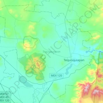
Name: Tequisquiapan topographic map, elevation, terrain.
Location: Tequisquiapan, Querétaro, Mexico (20.43158 -100.08496 20.65293 -99.82812)
Average elevation: 1,988 m
Minimum elevation: 1,850 m
Maximum elevation: 2,711 m
Thank you for supporting this site ❤️
Make a donation
Make a donation
Gear up for your next adventure:
As an Amazon Associate, this site earns from qualifying purchases at no extra cost to you.