
City of San Marino topographic map
Interactive map
Click on the map to display elevation.
City of San Marino
The city is known for its long, winding cobblestoned streets, as its altitude and steep approach put it beyond the reach of the San Marino Superhighway. San Marino is also notable in that cars are prohibited in much of the city center.
About this map
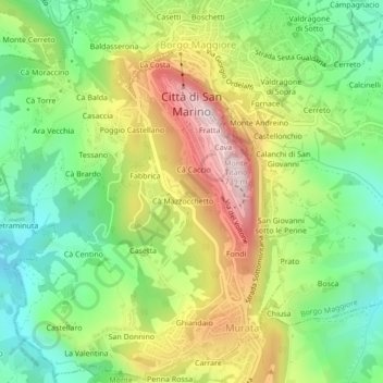
Name: City of San Marino topographic map, elevation, terrain.
Location: City of San Marino, 47890, San Marino (43.91413 12.41193 43.94259 12.45674)
Average elevation: 420 m
Minimum elevation: 221 m
Maximum elevation: 708 m
Other topographic maps
Click on a map to view its topography, its elevation and its terrain.
Monte Titano
San Marino > City of San Marino
Set in the Mediterranean zone the vegetation is typical influenced by elevation variations. Numerous trees inhabit the mountain, including chestnuts, oaks, laburnum, cypress, fir trees and some shrubs and asparagus, typical of the driest areas, such as the territory in the Three Towers of San Marino vicinity.…
Average elevation: 434 m