
Santa Claus topographic map
Interactive map
Click on the map to display elevation.
About this map
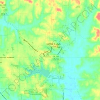
Name: Santa Claus topographic map, elevation, terrain.
Location: Santa Claus, Spencer County, Indiana, 47579, United States (38.08941 -86.97974 38.15691 -86.89805)
Average elevation: 143 m
Minimum elevation: 121 m
Maximum elevation: 185 m
Other topographic maps
Click on a map to view its topography, its elevation and its terrain.
Rock Hill
United States > Indiana > Spencer County
Rock Hill, Spencer County, Indiana, United States
Average elevation: 124 m
Dale
United States > Indiana > Spencer County
Dale, Spencer County, Indiana, United States
Average elevation: 138 m
Rockport
United States > Indiana > Spencer County
Rockport, Spencer County, Indiana, United States
Average elevation: 121 m
Ritchie
United States > Indiana > Spencer County > Ritchie
Ritchie, Spencer County, Indiana, 57611, United States
Average elevation: 127 m