
The Park at Haleland Park topographic map
Interactive map
Click on the map to display elevation.
About this map
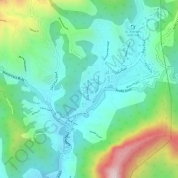
Name: The Park at Haleland Park topographic map, elevation, terrain.
Location: The Park at Haleland Park, Diego Martin, Trinidad and Tobago (10.71261 -61.50851 10.71384 -61.50774)
Average elevation: 200 m
Minimum elevation: 53 m
Maximum elevation: 547 m
Other topographic maps
Click on a map to view its topography, its elevation and its terrain.
Point Cumana
Trinidad and Tobago > Diego Martin
Point Cumana, Diego Martin, 110712, Trinidad and Tobago
Average elevation: 70 m
Chacachacare
Trinidad and Tobago > Diego Martin > Chacachacare Island
Chacachacare, Chacachacare Island, Diego Martin, Trinidad and Tobago
Average elevation: 18 m
Maraval River
Trinidad and Tobago > Diego Martin > Maraval
Maraval River, Maraval, Diego Martin, 190130, Trinidad and Tobago
Average elevation: 49 m
Diego Martin
Trinidad and Tobago > Diego Martin
Diego Martin, Trinidad and Tobago
Average elevation: 139 m