
Brennan's Hill topographic map
Interactive map
Click on the map to display elevation.
About this map
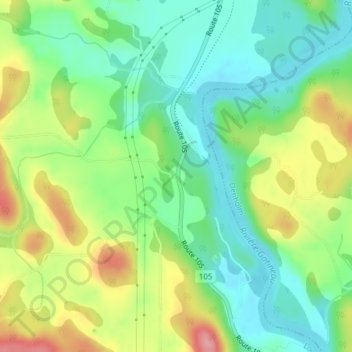
Name: Brennan's Hill topographic map, elevation, terrain.
Average elevation: 143 m
Minimum elevation: 99 m
Maximum elevation: 216 m
Other topographic maps
Click on a map to view its topography, its elevation and its terrain.
Baie de Paugan
Canada > Québec > La Vallée-de-la-Gatineau > Low
Baie de Paugan, Low, La Vallée-de-la-Gatineau, Outaouais, Québec, J0X 2C0, Canada
Average elevation: 145 m
Lac Sinclair
Canada > Québec > La Vallée-de-la-Gatineau > Low
Lac Sinclair, Low, La Vallée-de-la-Gatineau, Outaouais, Québec, Canada
Average elevation: 252 m
Venosta
Canada > Québec > La Vallée-de-la-Gatineau > Low
Venosta, Low, La Vallée-de-la-Gatineau, Outaouais, Québec, Canada
Average elevation: 171 m