
Make a donation
Gear up for your next adventure:
As an Amazon Associate, this site earns from qualifying purchases at no extra cost to you.
Upper Hunza Tehsil topographic map
Click on the map to display elevation.
Make a donation
Gear up for your next adventure:
As an Amazon Associate, this site earns from qualifying purchases at no extra cost to you.
About this map
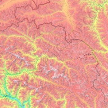
Name: Upper Hunza Tehsil topographic map, elevation, terrain.
Average elevation: 4,510 m
Minimum elevation: 1,379 m
Maximum elevation: 7,721 m
Make a donation
Gear up for your next adventure:
As an Amazon Associate, this site earns from qualifying purchases at no extra cost to you.
Other topographic maps
Click on a map to view its topography, its elevation and its terrain.
Make a donation
Gear up for your next adventure:
As an Amazon Associate, this site earns from qualifying purchases at no extra cost to you.
Ultar Peak
Pakistan > Gilgit-Baltistan > Hunza District
The first two summits were made in 1996 by two separate Japanese expeditions, the first on 11 July from the Tokai section of the Japanese Alpine Club led by Akito Yamazaki, and the second led by Ken Takahashi. The first summit team comprised Yamazaki and Kiyoshi Matsuoka (who died one year later on the nearby…
Average elevation: 6,458 m
Make a donation
Gear up for your next adventure:
As an Amazon Associate, this site earns from qualifying purchases at no extra cost to you.