
Höntrup topographic map
Interactive map
Click on the map to display elevation.
About this map
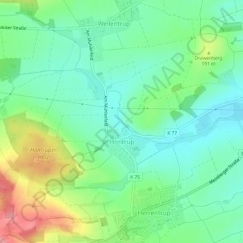
Name: Höntrup topographic map, elevation, terrain.
Location: Höntrup, Blomberg, Kreis Lippe, Nordrhein-Westfalen, Deutschland (51.92226 9.00928 51.93757 9.04438)
Average elevation: 167 m
Minimum elevation: 136 m
Maximum elevation: 231 m
Other topographic maps
Click on a map to view its topography, its elevation and its terrain.
Kleinenmarpe
Deutschland > Nordrhein-Westfalen > Kreis Lippe > Blomberg
Kleinenmarpe, Blomberg, Kreis Lippe, Nordrhein-Westfalen, Deutschland
Average elevation: 169 m
Kleinenmarpe
Deutschland > Nordrhein-Westfalen > Kreis Lippe > Blomberg
Kleinenmarpe, Blomberg, Kreis Lippe, Nordrhein-Westfalen, Deutschland
Average elevation: 169 m
Donop
Deutschland > Nordrhein-Westfalen > Kreis Lippe > Blomberg
Donop, Blomberg, Kreis Lippe, Nordrhein-Westfalen, Deutschland
Average elevation: 160 m
Cappel
Deutschland > Nordrhein-Westfalen > Kreis Lippe > Blomberg > Cappel
Cappel, Blomberg, Kreis Lippe, Nordrhein-Westfalen, Deutschland
Average elevation: 179 m
Dalborn
Deutschland > Nordrhein-Westfalen > Kreis Lippe > Blomberg > Dalborn
Dalborn, Blomberg, Kreis Lippe, Nordrhein-Westfalen, Deutschland
Average elevation: 155 m