Geolocate

Chequerec topographic map

Click on the map to display elevation.

About this map

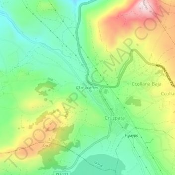
Name: Chequerec topographic map, elevation, terrain.

Location: Chequerec, Maras, Province of Urubamba, Cusco, Peru (-13.39675 -72.14333 -13.35675 -72.10333)

Average elevation: 3,603 m

Minimum elevation: 3,431 m

Maximum elevation: 3,880 m

Gear up for your next adventure:

🧘Folding Sit Mats - Dry and warm seat for map-reading breaks on damp ground
💧Hydration Reservoirs - Convenient water bladders for hands-free drinking on the move
🧦Hiking Socks - Breathable socks designed to prevent blisters on long walks
🧣Fleece Neck Warmers - Extra insulation for winter topographic surveys
🥾Trekking Poles - Poles to improve stability on uneven terrain

As an Amazon Associate, this site earns from qualifying purchases at no extra cost to you.