
Make a donation
Gear up for your next adventure:
As an Amazon Associate, this site earns from qualifying purchases at no extra cost to you.
Stockade Lake topographic map
Click on the map to display elevation.
Make a donation
Gear up for your next adventure:
As an Amazon Associate, this site earns from qualifying purchases at no extra cost to you.
About this map
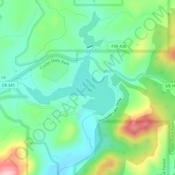
Name: Stockade Lake topographic map, elevation, terrain.
Location: Stockade Lake, Custer County, South Dakota, United States (43.76457 -103.53080 43.77326 -103.50989)
Average elevation: 1,616 m
Minimum elevation: 1,554 m
Maximum elevation: 1,757 m
Make a donation
Gear up for your next adventure:
As an Amazon Associate, this site earns from qualifying purchases at no extra cost to you.
Other topographic maps
Click on a map to view its topography, its elevation and its terrain.
Custer
United States > South Dakota > Custer County
Winter weather is dominated by the conflict between cold Arctic air moving south from Canada, and very warm chinook winds which can produce exceptionally high winter temperatures for the latitude and altitude. For instance, January 19 of 1963 saw the coldest temperature ever of −43 °F (−41.7 °C), yet in…
Average elevation: 1,660 m
Sylvan Lake
United States > South Dakota > Custer County > Sylvan Lake Resort
Average elevation: 1,891 m
Make a donation
Gear up for your next adventure:
As an Amazon Associate, this site earns from qualifying purchases at no extra cost to you.
Make a donation
Gear up for your next adventure:
As an Amazon Associate, this site earns from qualifying purchases at no extra cost to you.