
Malkangiri topographic map
Interactive map
Click on the map to display elevation.
About this map
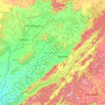
Name: Malkangiri topographic map, elevation, terrain.
Location: Malkangiri, Odisha, India (17.80278 81.38462 18.73271 82.44077)
Average elevation: 454 m
Minimum elevation: 45 m
Maximum elevation: 1,474 m
Other topographic maps
Click on a map to view its topography, its elevation and its terrain.
Bhitarkanika National Park
Bhitarkanika National Park, Rajnagar, Kendrapara District, Odisha, India
Average elevation: 3 m
Tej
India > Odisha > Thuamul Rampur
Tej, Thuamul Rampur, Kalahandi, Odisha, India
Average elevation: 736 m
Bhubaneshwar
India > Odisha > Bhubaneshwar
Bhubaneshwar, Bhubaneswar Municipal Corporation, Bhubaneswar (M.Corp.), Khordha, Odisha, 751001, India
Average elevation: 30 m