
Wolfsschlucht (Unterer Wasserfall) topographic map
Interactive map
Click on the map to display elevation.
About this map
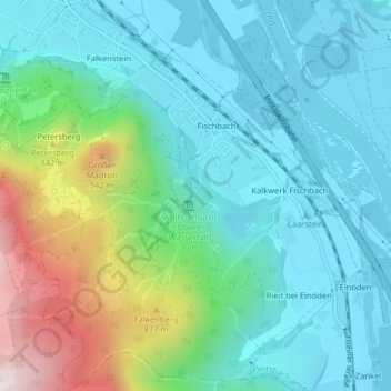
Name: Wolfsschlucht (Unterer Wasserfall) topographic map, elevation, terrain.
Average elevation: 612 m
Minimum elevation: 454 m
Maximum elevation: 1,115 m
Other topographic maps
Click on a map to view its topography, its elevation and its terrain.
Mutterberg
Duitsland > Beieren > Landkreis Rosenheim > Flintsbach am Inn
Mutterberg, Flintsbach am Inn, Landkreis Rosenheim, Beieren, 83098, Duitsland
Average elevation: 1,061 m