
Čierny Balog topographic map
Interactive map
Click on the map to display elevation.
About this map
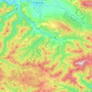
Name: Čierny Balog topographic map, elevation, terrain.
Average elevation: 772 m
Minimum elevation: 466 m
Maximum elevation: 1,312 m
Other topographic maps
Click on a map to view its topography, its elevation and its terrain.
Kráľova hoľa
Slovakia > Region of Banská Bystrica > District of Brezno
Kráľova hoľa (Slovak pronunciation: [ˈkraːʎɔʋa ˈɦɔʎa]; German: Königsberg; Hungarian: Király-hegy, literally "King's Mountain") is the highest mountain (1,946 m) of the eastern part of the Low Tatras in central Slovakia. Four rivers rise at its foot: Čierny Váh, Hnilec, Hornád, and Hron. The…
Average elevation: 1,653 m
Chopok
Slovakia > Region of Banská Bystrica > District of Brezno > Horná Lehota
Average elevation: 1,642 m