
Koohrang topographic map
Interactive map
Click on the map to display elevation.
About this map
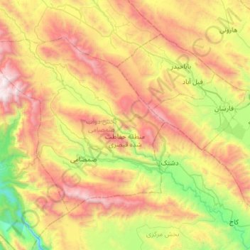
Name: Koohrang topographic map, elevation, terrain.
Average elevation: 2,511 m
Minimum elevation: 1,353 m
Maximum elevation: 4,120 m
Other topographic maps
Click on a map to view its topography, its elevation and its terrain.
Zard Kuh
Iran > Chaharmahal and Bakhtiyari Province > Kuhrang County > شهریاری
Average elevation: 3,808 m
Chelgerd
Iran > Chaharmahal and Bakhtiyari Province > Kuhrang County > Chelgerd
Average elevation: 2,477 m