
Make a donation
Gear up for your next adventure:
As an Amazon Associate, this site earns from qualifying purchases at no extra cost to you.
Goshen topographic map
Click on the map to display elevation.
Make a donation
Gear up for your next adventure:
As an Amazon Associate, this site earns from qualifying purchases at no extra cost to you.
Goshen
Settlements in the town include Goshen, near the town's western border, and Goshen Four Corners, in the center of the southern part of town. Vermont Route 73 runs east–west through Goshen, passing through Goshen Four Corners, and crossing the crest of the Green Mountains at Brandon Gap (elevation 2,183 ft or 665 m) near the town's east border. The Long Trail crosses Route 73 at Brandon Gap and passes over the summits of Mount Horrid (3,216 ft or 980 m) and Cape Lookoff Mountain (3,350 ft or 1,020 m) within Goshen. Goshen Mountain (3,292 ft or 1,003 m) is in the southeast corner of the town. Most of Goshen lies within the Green Mountain National Forest.
Make a donation
Gear up for your next adventure:
As an Amazon Associate, this site earns from qualifying purchases at no extra cost to you.
About this map
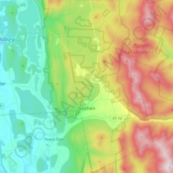
Name: Goshen topographic map, elevation, terrain.
Location: Goshen, Addison County, Vermont, United States (43.80486 -73.04002 43.92284 -72.95974)
Average elevation: 463 m
Minimum elevation: 111 m
Maximum elevation: 1,063 m
Make a donation
Gear up for your next adventure:
As an Amazon Associate, this site earns from qualifying purchases at no extra cost to you.
Other topographic maps
Click on a map to view its topography, its elevation and its terrain.
Abbey Pond Cascades (lower)
United States > Vermont > Addison County > Middlebury
Average elevation: 305 m
Make a donation
Gear up for your next adventure:
As an Amazon Associate, this site earns from qualifying purchases at no extra cost to you.
Lake Dunmore
United States > Vermont > Addison County > Salisbury > Lake Dunmore
Average elevation: 192 m
Make a donation
Gear up for your next adventure:
As an Amazon Associate, this site earns from qualifying purchases at no extra cost to you.