
Beulah topographic map
Click on the map to display elevation.
About this map
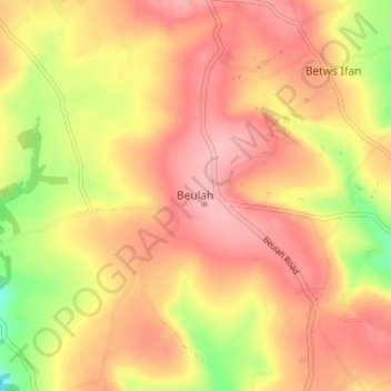
Name: Beulah topographic map, elevation, terrain.
Location: Beulah, Ceredigion, Wales, SA38 9QB, United Kingdom (52.06723 -4.52187 52.10723 -4.48187)
Average elevation: 139 m
Minimum elevation: 61 m
Maximum elevation: 184 m
Ceredigion trails, hiking, mountain biking, running and outdoor activities
Other topographic maps
Click on a map to view its topography, its elevation and its terrain.
Newcastle Emlyn Castle
United Kingdom > Wales > Ceredigion > Adpar > Bryndioddef
Average elevation: 78 m