
Puerto Iguazú topographic map
Interactive map
Click on the map to display elevation.
Puerto Iguazú
The hot season lasts for up to 6 months or more, with temperatures reaching between 30 and 35 °C (86 and 95 °F) on most days, and dropping to 18 to 24 °C (64 to 75 °F) at night. Thunderstorms with heavy rains bring relief when the heat becomes too intense. The cool season runs from late April to mid September, with daily highs reaching an average of 21 °C (70 °F) and a low of 11 °C (52 °F) in June. These averages are reached through an alternating weather pattern, with several days with northerly winds and temperatures of around 28 °C (82 °F) or higher and warm nights over 15 °C (59 °F) giving way, in a very sudden manner, to cool, rainy weather and temperatures between 10 and 15 °C (50 and 59 °F) for a few days, then to dry, sunny weather and colder nights (around 5 °C, or 41F, and sometimes much lower) and pleasant days in the 15 to 20 °C (59 to 68 °F) range, and a gradual increase in temperatures as winds rotate to the north again. Frost is rare but does occur on some winters, and temperatures within a few degrees of freezing occur every winter. The record low is −4.9 °C (23.2 °F), a surprisingly low value given the latitude, the vegetation and the low elevation of the area.
About this map
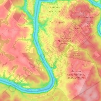
Name: Puerto Iguazú topographic map, elevation, terrain.
Location: Puerto Iguazú, Departamento Iguazú, Misiones, Argentina (-25.67713 -54.59481 -25.59242 -54.54178)
Average elevation: 184 m
Minimum elevation: 87 m
Maximum elevation: 245 m