
Thank you for supporting this site ❤️
Make a donation
Make a donation
Gear up for your next adventure:
As an Amazon Associate, this site earns from qualifying purchases at no extra cost to you.
Blenheim topographic map
Click on the map to display elevation.
Thank you for supporting this site ❤️
Make a donation
Make a donation
Gear up for your next adventure:
As an Amazon Associate, this site earns from qualifying purchases at no extra cost to you.
About this map
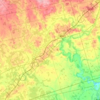
Name: Blenheim topographic map, elevation, terrain.
Location: Blenheim, Blandford-Blenheim, Oxford County, Ontario, Canada (43.15114 -80.67639 43.34810 -80.43654)
Average elevation: 300 m
Minimum elevation: 240 m
Maximum elevation: 364 m
Thank you for supporting this site ❤️
Make a donation
Make a donation
Gear up for your next adventure:
As an Amazon Associate, this site earns from qualifying purchases at no extra cost to you.