Geolocate

Bramshott Common topographic map

Click on the map to display elevation.

About this map

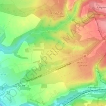
Name: Bramshott Common topographic map, elevation, terrain.

Location: Bramshott Common, Bramshott and Liphook, Bramshott, East Hampshire, Hampshire, England, United Kingdom (51.09106 -0.78129 51.09866 -0.75899)

Average elevation: 148 m

Minimum elevation: 98 m

Maximum elevation: 193 m

Hampshire trails, hiking, mountain biking, running and outdoor activities

Other topographic maps

Click on a map to view its topography, its elevation and its terrain.

Gear up for your next adventure:

🧦Merino Wool Hiking Socks - Moisture-wicking socks to prevent blisters during long mountain walks
👖Packable Overtrousers - Quick-deploy rain protection for legs in sudden storms
🧭Emergency Beacons - Safety beacons for remote outdoor locations
🧼Technical Clothing Wash - Special soap to clean and restore waterproof membranes
🎿Telescopic Trekking Poles - Reduces knee strain on steep topographic descents

As an Amazon Associate, this site earns from qualifying purchases at no extra cost to you.