
Make a donation
Gear up for your next adventure:
As an Amazon Associate, this site earns from qualifying purchases at no extra cost to you.
Villers-Saint-Ghislain topographic map
Click on the map to display elevation.
Make a donation
Gear up for your next adventure:
As an Amazon Associate, this site earns from qualifying purchases at no extra cost to you.
About this map
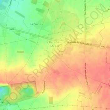
Name: Villers-Saint-Ghislain topographic map, elevation, terrain.
Location: Villers-Saint-Ghislain, Mons, Hainaut, Wallonie, 7031, Belgique (50.41778 4.02858 50.43931 4.06104)
Average elevation: 74 m
Minimum elevation: 39 m
Maximum elevation: 96 m
Make a donation
Gear up for your next adventure:
As an Amazon Associate, this site earns from qualifying purchases at no extra cost to you.
Other topographic maps
Click on a map to view its topography, its elevation and its terrain.
Mons
Belgique > Hainaut > Mons > Mons
Le relief de la commune de Mons est influencé par la vallée de la Haine, rivière qui s’écoule d’est en ouest au nord de la ville avant de rejoindre l'Escaut en France. La Trouille, affluent de la Haine (Direction Sud-Nord) se jette dans la Haine au niveau de Jemappes. Le nord et le sud de la vallée de…
Average elevation: 91 m
Make a donation
Gear up for your next adventure:
As an Amazon Associate, this site earns from qualifying purchases at no extra cost to you.