
Provincia de Chiloé topographic map
Interactive map
Click on the map to display elevation.
About this map
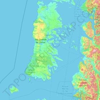
Name: Provincia de Chiloé topographic map, elevation, terrain.
Location: Provincia de Chiloé, Región de Los Lagos, Chile (-43.88384 -75.12745 -41.75748 -72.93034)
Average elevation: 156 m
Minimum elevation: 0 m
Maximum elevation: 2,436 m
Other topographic maps
Click on a map to view its topography, its elevation and its terrain.
Puerto Varas
Chile > Región de Los Lagos > Provincia de Llanquihue
Puerto Varas, Provincia de Llanquihue, Región de Los Lagos, Chile
Average elevation: 252 m
Puerto Montt
Chile > Región de Los Lagos > Puerto Montt
Puerto Montt, Provincia de Llanquihue, Región de Los Lagos, Chile
Average elevation: 175 m
Isla Grande de Chiloé
Chile > Región de Los Lagos > Chonchi
Isla Grande de Chiloé, Chonchi, Provincia de Chiloé, Región de Los Lagos, Chile
Average elevation: 44 m