Geolocate

Rävshult topographic map

Click on the map to display elevation.

About this map

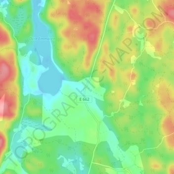
Name: Rävshult topographic map, elevation, terrain.

Location: Rävshult, Kinda kommun, Östergötland County, Sweden (57.94907 15.94620 57.98907 15.98620)

Average elevation: 140 m

Minimum elevation: 102 m

Maximum elevation: 198 m

Other topographic maps

Click on a map to view its topography, its elevation and its terrain.

Kinda kommun

Sweden > Östergötland County

Average elevation: 133 m

Navestad

Sweden > Östergötland County > Norrköping

Average elevation: 34 m

Vadstena

Sweden > Östergötland County

Average elevation: 98 m

Illern

Sweden > Östergötland County > Linköping

Average elevation: 72 m

Nässja

Sweden > Östergötland County

Average elevation: 91 m

Halgen

Sweden > Östergötland County

Average elevation: 88 m

Mjölby kommun

Sweden > Östergötland County

Average elevation: 123 m

Boxholms kommun

Sweden > Östergötland County

Average elevation: 169 m

Järstad

Sweden > Östergötland County

Average elevation: 82 m

Gear up for your next adventure:

📚UK Hiking Guidebooks - Detailed route descriptions for the Lake District, Peaks, and Highlands
📦Compression Sacks - Reduce backpack volume efficiently
🧷Tenacious Repair Tape - Instant fix for torn tents, jackets, or dry bags
🍲Portable Camping Stoves - Fast-boiling stoves for hot meals on remote topographic survey trips
🎒Hiking Child Carriers - Explore the outdoors with the whole family safely

As an Amazon Associate, this site earns from qualifying purchases at no extra cost to you.