
Sawin topographic map
Interactive map
Click on the map to display elevation.
About this map
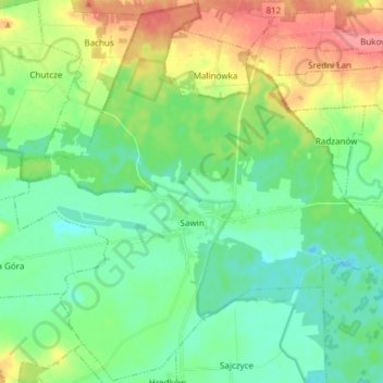
Name: Sawin topographic map, elevation, terrain.
Average elevation: 187 m
Minimum elevation: 164 m
Maximum elevation: 234 m
Other topographic maps
Click on a map to view its topography, its elevation and its terrain.
Zaporoże
Poland > Lublin Voivodeship > Chełm County > Busówno-Kolonia
Zaporoże, Busówno-Kolonia, gmina Wierzbica, Chełm County, Lublin Voivodeship, 22-150, Poland
Average elevation: 196 m
Kolonia Pierwsza
Poland > Lublin Voivodeship > Chełm County > Nowokajetanówka
Kolonia Pierwsza, Nowokajetanówka, gmina Dubienka, Chełm County, Lublin Voivodeship, Poland
Average elevation: 179 m