
Make a donation
Gear up for your next adventure:
As an Amazon Associate, this site earns from qualifying purchases at no extra cost to you.
Capileira topographic map
Click on the map to display elevation.
Make a donation
Gear up for your next adventure:
As an Amazon Associate, this site earns from qualifying purchases at no extra cost to you.
Capileira
Capileira is the highest and most northerly of the three villages in the gorge of the Poqueira river in the La Alpujarra district of the province of Granada, in Spain. It is located at latitude 36° 57' N and longitude 3° 21' W, about 1 km north of Bubión. Its altitude is officially recorded as 1436 metres, though there is a considerable altitude difference between the oldest part of the village, which is at the lower, southern end, and the highest part, where tourist-oriented development is currently concentrated. The area of the municipality is 57 km².
Make a donation
Gear up for your next adventure:
As an Amazon Associate, this site earns from qualifying purchases at no extra cost to you.
About this map
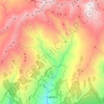
Name: Capileira topographic map, elevation, terrain.
Average elevation: 2,384 m
Minimum elevation: 1,117 m
Maximum elevation: 3,472 m
Make a donation
Gear up for your next adventure:
As an Amazon Associate, this site earns from qualifying purchases at no extra cost to you.
Other topographic maps
Click on a map to view its topography, its elevation and its terrain.
Pico de Mulhacén
Spain > Andalusia > Partido Judicial de Órgiva > Trevélez
Mulhacén ([mulaˈθen]), with an elevation of 3,479 metres (11,414 ft), is the highest mountain in peninsular Spain and in all of the Iberian Peninsula. It is part of the Sierra Nevada range in the Penibaetic System. It is named after Abu'l-Hasan Ali, known as Muley Hacén in Spanish, the penultimate Muslim…
Average elevation: 3,070 m