
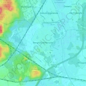
Bergholz-Rehbrücke topographic map
Interactive map
Click on the map to display elevation.
About this map
Name: Bergholz-Rehbrücke topographic map, elevation, terrain.
Average elevation: 41 m
Minimum elevation: 30 m
Maximum elevation: 102 m
Other topographic maps
Click on a map to view its topography, its elevation and its terrain.
Ferch
Duitsland > Brandenburg > Potsdam-Mittelmark > Ferch
Ferch, Schwielowsee, Potsdam-Mittelmark, Brandenburg, Duitsland
Average elevation: 58 m
Treuenbrietzen
Duitsland > Brandenburg > Potsdam-Mittelmark > Treuenbrietzen
Treuenbrietzen, Potsdam-Mittelmark, Brandenburg, 14929, Duitsland
Average elevation: 81 m