
Town of Cheektowaga topographic map
Interactive map
Click on the map to display elevation.
About this map
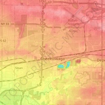
Name: Town of Cheektowaga topographic map, elevation, terrain.
Location: Town of Cheektowaga, Erie County, New York, United States (42.86351 -78.79990 42.95348 -78.69687)
Average elevation: 201 m
Minimum elevation: 147 m
Maximum elevation: 223 m
Other topographic maps
Click on a map to view its topography, its elevation and its terrain.
Onondaga Escarpment
United States > New York > Erie County > Village of Akron
Average elevation: 236 m