Geolocate

Ullern topographic map

Click on the map to display elevation.

About this map

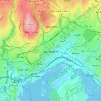
Name: Ullern topographic map, elevation, terrain.

Location: Ullern, Oslo, Norway (59.90978 10.62533 59.94191 10.70866)

Average elevation: 58 m

Minimum elevation: -1 m

Maximum elevation: 190 m

Other topographic maps

Click on a map to view its topography, its elevation and its terrain.

Oslo

Norway > Oslo

Average elevation: 186 m

Telemark

Norway > Oslo

Average elevation: 10 m

Stensrud

Norway > Oslo

Average elevation: 169 m

Huk

Norway > Oslo

Average elevation: 4 m

Prekestolen

Norway > Oslo

Average elevation: 427 m

Hardanger

Norway > Oslo

Average elevation: 8 m

Barlindåsen

Norway > Oslo

Average elevation: 318 m

Gear up for your next adventure:

🧦Hiking Socks - Breathable socks designed to prevent blisters on long walks
🧰Survival Kits - Emergency tools for remote environments
🕶️Glacier Goggles - Maximum protection for high-altitude snow topography
👟Heavy Duty Boot Laces - Always carry a spare for your hiking footwear
🛰️Satellite Messengers - Emergency communication devices for areas without mobile signal

As an Amazon Associate, this site earns from qualifying purchases at no extra cost to you.