
Thank you for supporting this site ❤️
Make a donation
Make a donation
Gear up for your next adventure:
As an Amazon Associate, this site earns from qualifying purchases at no extra cost to you.
Gonder topographic map
Click on the map to display elevation.
Thank you for supporting this site ❤️
Make a donation
Make a donation
Gear up for your next adventure:
As an Amazon Associate, this site earns from qualifying purchases at no extra cost to you.
About this map
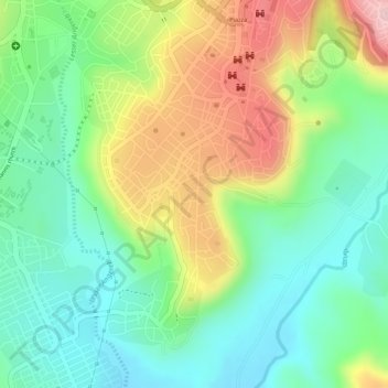
Name: Gonder topographic map, elevation, terrain.
Location: Gonder, North Gondar, Amhara Region, 6200, Ethiopia (12.59000 37.45667 12.61000 37.47667)
Average elevation: 2,126 m
Minimum elevation: 2,033 m
Maximum elevation: 2,266 m
Thank you for supporting this site ❤️
Make a donation
Make a donation
Gear up for your next adventure:
As an Amazon Associate, this site earns from qualifying purchases at no extra cost to you.