
Make a donation
Gear up for your next adventure:
As an Amazon Associate, this site earns from qualifying purchases at no extra cost to you.
Corella topographic map
Click on the map to display elevation.
Make a donation
Gear up for your next adventure:
As an Amazon Associate, this site earns from qualifying purchases at no extra cost to you.
Corella
La ciudad de Corella está situada en la parte Sur de la Comunidad Foral de Navarra dentro de la región geográfica de la Ribera de Navarra a una altitud de 370 msnm. Su término municipal tiene una superficie de 83,3 km² y limita al norte con el municipio de Alfaro en la comunidad autónoma de La Rioja y con el de Castejón, al este con el de Tudela, al sur con los de Cintruénigo y Fitero y al oeste también con el de Alfaro.
Make a donation
Gear up for your next adventure:
As an Amazon Associate, this site earns from qualifying purchases at no extra cost to you.
About this map
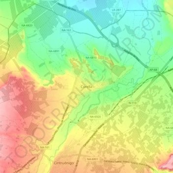
Name: Corella topographic map, elevation, terrain.
Location: Corella, Navarra, 31591, España (42.07521 -1.82937 42.15521 -1.74937)
Average elevation: 366 m
Minimum elevation: 307 m
Maximum elevation: 440 m
Make a donation
Gear up for your next adventure:
As an Amazon Associate, this site earns from qualifying purchases at no extra cost to you.