Geolocate

Al Karak topographic map

Click on the map to display elevation.

About this map
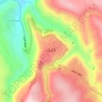
Name: Al Karak topographic map, elevation, terrain.

Location: Al Karak, Karak Sub-District, Karak Qasabah District, Karak, 61110, Jordan (31.18037 35.70056 31.18835 35.70945)

Average elevation: 913 m

Minimum elevation: 687 m

Maximum elevation: 1,094 m

Other topographic maps

Click on a map to view its topography, its elevation and its terrain.

Zahum

Jordan > Karak > Karak Sub-District

Average elevation: 945 m

Al Adnanyah

Jordan > Karak > Karak Sub-District

Average elevation: 1,137 m

Al Thaniya

Jordan > Karak > Karak Sub-District

Average elevation: 1,015 m

Al Manshiya

Jordan > Karak > Karak Sub-District

Average elevation: 1,012 m

الحوية

Jordan > Karak > Karak Sub-District

Average elevation: 1,072 m

Al Karak

Jordan > Karak > Karak Sub-District > Al Karak

Average elevation: 966 m

Gear up for your next adventure:

🧼Biodegradable Soap - Leave-no-trace hygiene for multi-day mountain treks
🔪Outdoor Multi-Tools - Versatile tools for gear repairs and food prep in the wild
🥾Women's Waterproof Hiking Boots - High-performance trekking boots designed for all-weather comfort
🧗Locking Carabiners - Secure gear to your pack or for light technical use
🧺Ultralight Dry Bags - Organize and waterproof your gear inside your rucksack

As an Amazon Associate, this site earns from qualifying purchases at no extra cost to you.