
Make a donation
Gear up for your next adventure:
As an Amazon Associate, this site earns from qualifying purchases at no extra cost to you.
Kalymnos topographic map
Click on the map to display elevation.
Make a donation
Gear up for your next adventure:
As an Amazon Associate, this site earns from qualifying purchases at no extra cost to you.
Kalymnos
Kalymnos is mostly mountainous with complicated topography. There are three main chains going from W-NW to E-SE, and a fourth which extends NW the length of the peninsula. The coastline is very irregular, with many sheltered coves. There are some springs, one among them being thermal. The soil is mainly limestone-based, but in the valleys, there is a compact bank of volcanic tuff, the relic of an ancient volcano, located in Vigles, between the villages of Myrties and Kantouni. The island is mainly barren, except for the two fertile valleys of Vathys and Pothia, where olives, oranges and vines are grown. There is also an ostrich farm in Argos, near the airport.
Make a donation
Gear up for your next adventure:
As an Amazon Associate, this site earns from qualifying purchases at no extra cost to you.
About this map
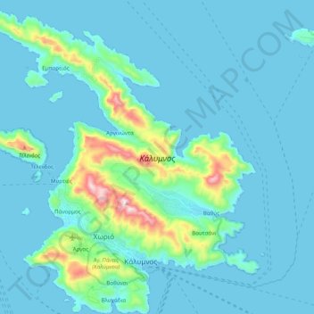
Name: Kalymnos topographic map, elevation, terrain.
Average elevation: 75 m
Minimum elevation: 0 m
Maximum elevation: 664 m
Make a donation
Gear up for your next adventure:
As an Amazon Associate, this site earns from qualifying purchases at no extra cost to you.
Other topographic maps
Click on a map to view its topography, its elevation and its terrain.