
Thank you for supporting this site ❤️
Make a donation
Make a donation
Gear up for your next adventure:
As an Amazon Associate, this site earns from qualifying purchases at no extra cost to you.
Nahan topographic map
Click on the map to display elevation.
Thank you for supporting this site ❤️
Make a donation
Make a donation
Gear up for your next adventure:
As an Amazon Associate, this site earns from qualifying purchases at no extra cost to you.
Nahan
Nahan is located at 30°33′N 77°18′E / 30.55°N 77.3°E / 30.55; 77.3. It has an average elevation of 932 metres.
Thank you for supporting this site ❤️
Make a donation
Make a donation
Gear up for your next adventure:
As an Amazon Associate, this site earns from qualifying purchases at no extra cost to you.
About this map
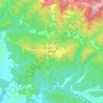
Name: Nahan topographic map, elevation, terrain.
Location: Nahan, Sirmaur, Himachal Pradesh, 173001, India (30.52018 77.25236 30.60018 77.33236)
Average elevation: 685 m
Minimum elevation: 379 m
Maximum elevation: 1,403 m
Thank you for supporting this site ❤️
Make a donation
Make a donation
Gear up for your next adventure:
As an Amazon Associate, this site earns from qualifying purchases at no extra cost to you.