Geolocate

Springfield topographic map

Click on the map to display elevation.

About this map

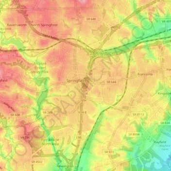
Name: Springfield topographic map, elevation, terrain.

Location: Springfield, Fairfax County, Virginia, 22150, United States (38.73804 -77.21878 38.81206 -77.15308)

Average elevation: 68 m

Minimum elevation: 6 m

Maximum elevation: 103 m

Gear up for your next adventure:

🛌Sleeping Bags - Warm and packable sleeping bags for outdoor nights
🔦Head Torches - Hands-free lighting for hiking and camping
🥤Hydration Bladders - Hands-free hydration systems for backpacks
🧘Folding Sit Mats - Dry and warm seat for map-reading breaks on damp ground
🧺Microfibre Travel Towels - Fast-drying and compact towels for wild swimming and camping

As an Amazon Associate, this site earns from qualifying purchases at no extra cost to you.