
Tournaboup topographic map
Interactive map
Click on the map to display elevation.
About this map
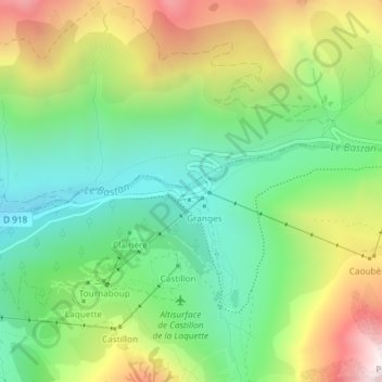
Name: Tournaboup topographic map, elevation, terrain.
Average elevation: 1,744 m
Minimum elevation: 1,364 m
Maximum elevation: 2,365 m
Other topographic maps
Click on a map to view its topography, its elevation and its terrain.
Super Barèges
France > Occitanie > Hautes-Pyrénées > Barèges
Super Barèges, Barèges, Argelès-Gazost, Hautes-Pyrénées, Occitanie, France métropolitaine, 65120, France
Average elevation: 2,069 m
Le Lienz
France > Occitanie > Hautes-Pyrénées > Barèges
Le Lienz, Barèges, Argelès-Gazost, Hautes-Pyrénées, Occitanie, France métropolitaine, 65120, France
Average elevation: 1,615 m