
Thank you for supporting this site ❤️
Make a donation
Make a donation
Gear up for your next adventure:
As an Amazon Associate, this site earns from qualifying purchases at no extra cost to you.
Catulun topographic map
Click on the map to display elevation.
Thank you for supporting this site ❤️
Make a donation
Make a donation
Gear up for your next adventure:
As an Amazon Associate, this site earns from qualifying purchases at no extra cost to you.
About this map
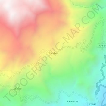
Name: Catulun topographic map, elevation, terrain.
Location: Catulun, Huancabamba, Provincia de Huancabamba, Piura, Perú (-5.19069 -79.49083 -5.15069 -79.45083)
Average elevation: 2,744 m
Minimum elevation: 2,050 m
Maximum elevation: 3,509 m
Thank you for supporting this site ❤️
Make a donation
Make a donation
Gear up for your next adventure:
As an Amazon Associate, this site earns from qualifying purchases at no extra cost to you.