Geolocate

Depoe Bay topographic map

Click on the map to display elevation.

About this map
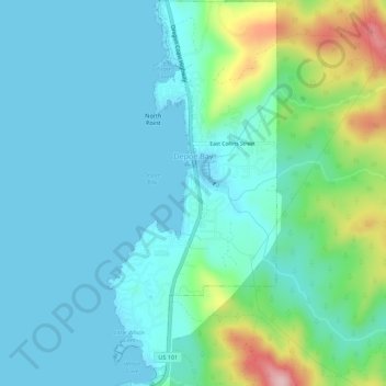
Name: Depoe Bay topographic map, elevation, terrain.

Location: Depoe Bay, Lincoln County, Oregon, United States (44.78707 -124.07425 44.82617 -124.04999)

Average elevation: 48 m

Minimum elevation: -2 m

Maximum elevation: 236 m

Other topographic maps

Click on a map to view its topography, its elevation and its terrain.

Bayshore

United States > Oregon > Lincoln County

Average elevation: 15 m

Otter Rock

United States > Oregon > Lincoln County

Average elevation: 6 m

Logsden

United States > Oregon > Lincoln County

Average elevation: 119 m

Tidewater

United States > Oregon > Lincoln County

Average elevation: 222 m

Seal Rock

United States > Oregon > Lincoln County

Average elevation: 6 m

Wakonda Beach

United States > Oregon > Lincoln County

Average elevation: 20 m

Tidewater

United States > Oregon > Lincoln County

Average elevation: 222 m

Beverly Beach

United States > Oregon > Lincoln County

Average elevation: 29 m

Eddyville

United States > Oregon > Lincoln County

Average elevation: 131 m

Agate Beach

United States > Oregon > Lincoln County > Newport

Average elevation: 42 m

Logsden

United States > Oregon > Lincoln County

Average elevation: 119 m

Gear up for your next adventure:

🚶Walking Pedometers - Simple distance tracking for casual trail walkers
📢Survival Whistles - Essential safety gear for signaling for help in mountain fog
🔋Solar Power Banks - Keep your GPS and phone charged during multi-day expeditions
🧢Thermal Beanie Hats - Prevent heat loss from the head in windy summit conditions
🌄Outdoor Binoculars - Compact binoculars for landscape observation

As an Amazon Associate, this site earns from qualifying purchases at no extra cost to you.