Geolocate

Whitewood topographic map

Click on the map to display elevation.

About this map

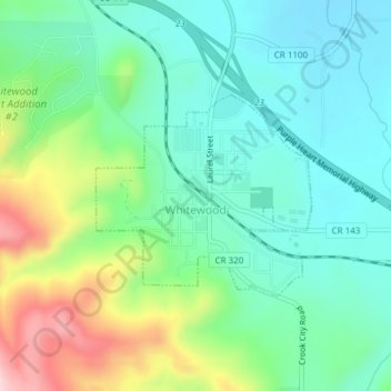
Name: Whitewood topographic map, elevation, terrain.

Location: Whitewood, Lawrence County, South Dakota, United States (44.45500 -103.64939 44.47388 -103.62843)

Average elevation: 1,134 m

Minimum elevation: 1,068 m

Maximum elevation: 1,297 m

Other topographic maps

Click on a map to view its topography, its elevation and its terrain.

Nemo

United States > South Dakota > Lawrence County

Average elevation: 1,490 m

Nahant

United States > South Dakota > Lawrence County

Average elevation: 1,806 m

Merritt

United States > South Dakota > Lawrence County

Average elevation: 1,601 m

Terry Peak

United States > South Dakota > Lawrence County

Average elevation: 1,940 m

Spearfish

United States > South Dakota > Lawrence County > Spearfish

Average elevation: 1,291 m

Gear up for your next adventure:

🗺️Ordnance Survey Maps - Essential paper maps for hiking across the UK national parks
👕Technical Hiking Tees - Moisture-management for high-exertion climbs
🦯Walking Poles - Supportive poles for long-distance walking
🎒Replacement Sternum Straps - Repair parts for hiking rucksacks
👟Waterproof Leg Gaiters - Keep mud and water out of your boots in boggy terrain

As an Amazon Associate, this site earns from qualifying purchases at no extra cost to you.